Kaeng
Krachan is located on the eastern slope
of the Tenasserim Mountain Range at the border of Burma (Myanmar). It
occupies the western half of P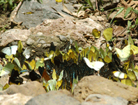 hetchaburi
Province (Amphur Kaeng Krachan and Amphur Nong Ya Plong) and a portion
of northern Prachuab Khiri Khan Province (Amphur Hua Hin). The National
Park was designated on June 12, 1981; its original borders encompassed
1.5 million rai. On April 20, 1983, Thalerng Thamrongnawasawad, Peramnent
Secretary of the Ministry of Agriculture and Cooperatives, presided over
the offical opening ceremony. On December 27, 1984,
the park area was extended, as proposed by the Hua Hin Environmental Conservation
Group, to cover the boundary
between Phetchaburi and Prachuab Khirikhan Provinces, bringing the total
area to over 1.8 million rai.
hetchaburi
Province (Amphur Kaeng Krachan and Amphur Nong Ya Plong) and a portion
of northern Prachuab Khiri Khan Province (Amphur Hua Hin). The National
Park was designated on June 12, 1981; its original borders encompassed
1.5 million rai. On April 20, 1983, Thalerng Thamrongnawasawad, Peramnent
Secretary of the Ministry of Agriculture and Cooperatives, presided over
the offical opening ceremony. On December 27, 1984,
the park area was extended, as proposed by the Hua Hin Environmental Conservation
Group, to cover the boundary
between Phetchaburi and Prachuab Khirikhan Provinces, bringing the total
area to over 1.8 million rai.
The
area, about 45 squares kilometers, consists of both ground and water
in reservoir. The vastly forest upper the Kang Kra Jan Dam is on complicated
mountain
ranges which the highest peak is 1,200 meters above sea level and approximately
high 500 meter above sea level. Most of the mountains are Granite Mountain,
few are Limestone Mountains, and many are full of fluoride. And also most
of the area is covered by rain forest so that is the source of Phet Buri
River and Pran Buri River. "Baan
Maka Chalet"
have location next to Kaeng Krachan
National Park
Google Map : N 12 50' 32.68" E 099 35' 30.16"
How to go to Baan Maka Chalet First Get on Rama 2 road and towards to Petchaburi for about 2 hours. From Wang-manow junction about 29-30 kms. You can see a short distance before reaching Petchaburi there is a new road bridge across the main highway. Turn left and drive across the road bridge which will take you onto the road heading towards Kaeng Krachan National Park. Follow this road for about 27-28 kms. until it reaches a T-junction; turn right here and follow the signs until reaching park HQ, about 41kms. pass Ampour Kaeng Krachan around 700 m. turn left cross the bridge and then go towards about 15 kms. turn left at junction which you can see parashoot tower then go toward until down hill,turn left at junction,after that 1.8 kms. You can see Ban Maka Chalet on the right.